Mapping and Monitoring Lake Ice using SAR Satellites
Torsten Geldsetzer and Joost van der Sanden, Natural Resources Canada, Canada Centre for Remote Sensing
Lake ice: Many thousands of freshwater lakes cover the northern landscape. Lake ice is thus an important part of the cryosphere, and its phenology affects a wide variety of natural and human activities. Lake ice controls the biological productivity of lake ecosystems, and the migration of species that depend on ice or open water. Lake ice determines the extraction of winter water for human use (shallow lakes can freeze to the bottom); and it is a component of ice roads, providing winter road access to remote locations. Lake ice also influences weather patterns and, thus, weather forecasting and climate modelling. The sensitivity of lake ice to air temperature makes it an effective indicator of climate change.
Ice characteristics: Lake ice phenology encompasses three key ice events: 1) freeze-up in the fall, 2) bottom freezing in the winter, and 3) break-up in the spring. Mapping and monitoring the intra-annual and inter-annual dates of these three ice events is a primary objective. The timing of these ice events relies mainly on air temperature, although wind, snow cover and lake size (area and depth) also play a role. In winter, most ice is floating; however, bottom freezing (grounding) may occur in shallow lakes, i.e. areas that are less than one or two metres deep. Ice characteristics of interest are: lake ice coverage (percent ice versus open water), ice type, ice thickness (usually less than two metres), and surface condition (snow cover, stage of melting, crystal structure).

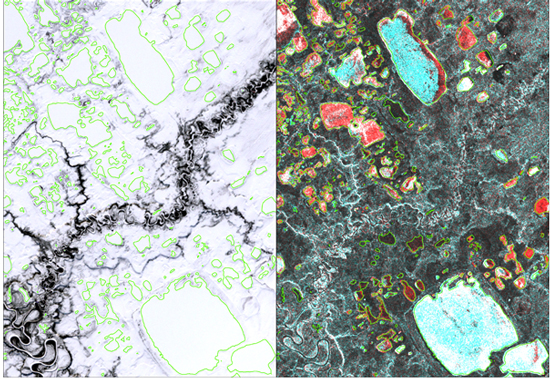
Figure 1. Ice- and snow-covered lakes in Vuntut NP, Yukon, late March 2009. The lakes are outlined in green. The left image is from the optical Landsat satellite. The right image is from the Radarsat-2 SAR satellite with both co- and cross-polarizations. The dark lakes are grounded ice; the red, blue and white areas on the lakes are three different types of floating ice.
SAR satellites: In Canada’s north, the mapping and monitoring of lake ice is especially challenging: covering vast and remote geographical areas during winter darkness and/or persistent cloud cover. Measurements at frequent intervals are necessary to map precise dates for ice events. Remote sensing satellites using Synthetic Aperture Radar (SAR) are ideally suited to this task.
SAR satellites send out and receive microwave radar signals, and can image the Earth’s surface during total darkness and through cloud cover (unlike optical satellites). SAR satellites record the received microwave signal as backscatter; the strength and character (e.g. polarization) of the backscatter is used to infer surface conditions. Microwave signals can penetrate ice and snow cover to varying degrees, enabling detection of water beneath the ice or within the snow cover.

Methods: Current research and development (R&D) is done in collaboration with Parks Canada and focuses on lakes in three of Canada’s most northerly National Parks (NP): Vuntut NP, Yukon; Tuktut Nogait NP, NWT; and Ukkusiksalik NP, Nunavut. This R&D involves four steps:
- Observing the SAR backscatter from lake ice in fall, winter and spring.
- Relating the backscatter to the geophysical properties of lake ice, to understand how microwaves interact with snow, ice and water.
- Developing methods to consistently discriminate lake ice from open water, or grounded ice from floating ice.
- Applying these methods operationally for automated mapping and monitoring of ice events.

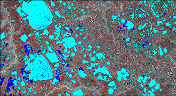
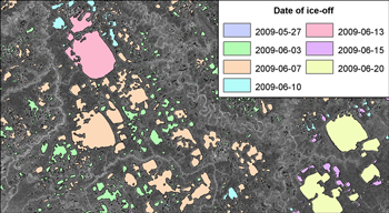
Results: Results thus far show that SAR satellites, providing both co-polarized (co-pol) and cross-polarized (cross-pol) images simultaneously, are excellent tools for mapping and monitoring lake ice. Such imagery is available from second-generation SAR satellites: RADARSAT-2, ALOS PALSAR, TerraSAR-X. In winter, grounded ice and floating ice are identified by either low or high co-pol backscatter, respectively. Differentiation between floating ice types is possible with the addition of cross-pol imagery (Figure 1). In spring, lake ice and open water are classified by their co- and cross-pol backscatter (Figure 2). During the early melt period, co-pol imagery is used because cross-pol backscatter is too low. However, during final ice break-up, cross-pol imagery is used when large areas of open water are present and wind-induced waves create co-pol backscatter very similar to that of ice. In winter, bottom freezing occurs quite slowly, and can be monitored using weekly or monthly SAR imagery. However, rapid changes during both fall freeze-up and spring break-up require SAR imagery every three to four days in order to accurately map and monitor these ice events (Figure 3).
Radarsat-2 Data and Products © MacDonald, Dettwiler and Associates Ltd. (2009) All Rights Reserved. Radarsat is an official mark of the Canadian Space Agency.
Page details
- Date modified: