Introduction - Atlantic Canada
Atlantic Canada includes the provinces of New Brunswick, Newfoundland and Labrador, Nova Scotia, and Prince Edward Island (Figure 1a, b). Newfoundland and Labrador has the largest area of the four provinces, more than three times the land area of the three Maritime Provinces combined, and extends from latitude 60 °23'N (Cape Chidley) to latitude 46°37'N (Cape Pine). Of the three Maritime Provinces, New Brunswick is the largest and Prince Edward Island the smallest. The southernmost point in Atlantic Canada is Cape Sable, NS (43 °28'N). With the exceptions of Churchill Falls, Labrador City and Wabush, NL, no community is more than 200 km from the nearest marine shoreline.
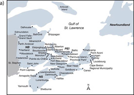
FIGURE 1a: Communities in the Atlantic provinces: New Brunswick, Nova Scotia, and Prince Edward Island.
larger image
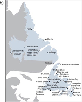
FIGURE 1b: Newfoundland and Labrador
larger image
1.1 DEMOGRAPHIC PROFILE
Atlantic Canada includes the entire region — the provinces of New Brunswick, Nova Scotia, Prince Edward Island, and Newfoundland and Labrador.
Maritime Canada (or the Maritimes) includes New Brunswick, Nova Scotia, and Prince Edward Island, but not Newfoundland and Labrador.
The total population of the four Atlantic Provinces was 2.34 million in 2005 (Statistics Canada, 2005a, b), virtually unchanged from 2004. While Newfoundland and Labrador and New Brunswick experienced a decline in population, Prince Edward Island and Nova Scotia showed an increase in population during the same period (Table 1). Considering that most communities of the region are aging (Table 1) and have average annual incomes below the national average, any impacts due to climate change will represent an additional challenge to these provinces.
| New Brunswick |
Newfound- land and Labrador |
Nova Scotia |
Prince Edward Island |
Canada | |
|---|---|---|---|---|---|
| Population, 2005 | 752 000 | 516 000 | 937 900 | 138 100 | 32 270 500 |
| Population change, 2004-2005 (%) | -0.01 | -0.25 | +0.04 | +0.14 | +0.9 |
| Net interprovincial migration, 2004-2005(1) | -1650 | -1875 | -473 | -222 | N/A |
| Population density, 2005 (persons/km2) | 10.3 | 1.27(2) | 17.0 | 24.4 | 3.2 |
| Urban (%)(3) | 50 | 58 | 56 | 45 | 80 |
| Ages 0-14 (%) | 16.1 | 15.7 | 16.2 | 17.7 | 17.6 |
| Ages 15-64 (%) | 69.9 | 71.2 | 69.5 | 68.2 | 69.3 |
| Ages 65+ (%) | 13.9 | 13.1 | 14.2 | 14.1 | 13.1 |
| Projected population by 2030 | 742 600 (-1.3%) |
490 000 (-5.3%) |
940 100 (+0.02%) |
141 500 (+2.1%) |
36 182 300 (+11.1%) |
1 includes migration between Canadian provinces, both within and outside Atlantic Canada; for all four provinces, the dominant destinations were Alberta and Ontario (Statistics Canada, 2005a, b)
2Newfoundland 4.38 persons/km2; Labrador 0.95 persons/km2
32001 census
1.2 ECONOMY
Atlantic Canada includes numerous rural communities, along with urban centres such as the Halifax Regional Municipality, Cape Breton Regional Municipality, Moncton, Saint John, Fredericton, Charlottetown and St. John’s. Substantial discrepancies exist between rural and urban areas, with rural communities generally marked by populations with fewer economic resources, leading to the out-migration phenomenon observed in rural Atlantic Canada. Population growth rates in Halifax (+4.6%) and Moncton (+3.6%) between 1996 and 2001 are in contrast to losses in rural areas (Statistics Canada, 2001b). Of the twenty regional economic zones throughout Newfoundland and Labrador, only five are projected to have population increases between 2006 and 2019 (Newfoundland and Labrador Department of Finance, 2007).
Socioeconomic differences between rural and urban areas can lead to differences in community vulnerability to the impacts of extreme weather events and climate change (Morrow, 1999; Alchorn and Blanchard, 2004; Catto and Hickman, 2004). Historically, a large part of the population of Atlantic Canada relied on natural resources, including fisheries, agriculture, forestry and mining.With globalization and changing demographics, however, Atlantic Canada has experienced a significant reduction of jobs in communities relying on a single resource-based industry (e.g. industrial Cape Breton, NS; Shippagan, NB; Stephenville and Harbour Breton, NL). Burgeo, NL is typical of many fishery-dependent communities: in May 2001, the employment rate for people aged 18 to 64 was 35%, in contrast to the provincial rate of 55% (Government of Newfoundland and Labrador, 2006). The urbanized areas of Atlantic Canada have been the main focus of the local economy, and have seen greater opportunities in the global market. This divergent regional development has produced a gap between rural and urban regions. The labour market has been transformed during the past several decades from having an important rural component, with a resource-based economy, to a labour force that relies mainly on technology and advanced knowledge to compete at the global market level. The workers with better skills can get new jobs, mostly in services and entrepreneurship. Many are now self-employed workers, bringing business and the economy of the Atlantic Provinces to national and international markets. Simultaneously, the resource-based rural and smaller communities are facing international competition, particularly in fish processing and paper manufacturing, as well as domestic competition, predominantly with potatoes and other agricultural products. In many rural areas, the response of some workers has been to leave Atlantic Canada in search of employment, or to accept positions in western Canada while maintaining permanent residences and leaving immediate family in Atlantic Canada. Both rural and urban economies are sensitive to changes in the global market. Job maintenance and creation are highly dependent on the competitiveness and productivity of businesses, and on intergovernmental and foreign policies. Access to marine transportation has helped this region contribute to Canada’s trade balance.With future climate change, this heavy reliance on marine and coastal systems and communities may increase vulnerability, especially if transportation and infrastructure are disrupted by storm events.
1.3 ABORIGINAL COMMUNITIES
Aboriginal communities, including Innu, Inuit and Migmag among others, have a distinctive set of socioeconomic conditions. Characteristically, these communities have higher proportions of young citizens (e.g. 43.1% of the population of Nain in 2001 was 19 years of age or younger; Government of Newfoundland and Labrador, 2006). Per capita earnings and incomes are lower than for the general populations of the region (e.g. for Lennox Island, PE, the median total income for persons 15 and over was $12 272 in 2001, compared with a provincial average of $18 880; Statistics Canada, 2001b). Education levels are generally lower as well (e.g. at Whycocomagh, NS, 29.4% of the population between ages 20 and 34 have not graduated from high school, compared with 16.1% of the general population of Nova Scotia; Statistics Canada, 2001b).
BOX 1 - Addressing climate change in Elsipogtog
Migmag communities of the New Brunswick eastern coast are concerned about the impacts of climate change on the sustainability of their traditions and access to natural resources. This is especially important for the traditional food and medicines found in salt marshes. The protection of traditional knowledge and resources is an important way for the Migmag to protect their culture.
 Sweetgrass (Hierochloa odorata)
A survey of traditional plants was completed in collaboration with the Elsipogtog Community to understand the potential impacts of climate change on their traditional resources. Field data were then combined into a digital elevation model (DEM), built using laser imaging detection and ranging (LIDAR) data. Several flooding scenarios integrating projections of sea-level rise and terrestrial subsidence (e.g. Carrera and Van íc?ek, 1988) were developed to evaluate the impacts of sea-level rise on the existing populations of sweetgrass and other medicinal plants located in salt marshes. Sweetgrass is a very important plant for Aboriginal communities. It is used in ceremonies as incense, to weave baskets, as ornaments and in teas. The modelling is an extension and new application of the Thompson et al. (2001) methodology, and based on the reconstruction of the model of the storm-surge events of January 21, 2000. Results show that, even under the most optimistic scenario, the flood line reached the forest, flooding all the salt marshes.
Planning is now the main focus of the community. Historically, Aboriginal people did not build permanent housing along the coast, as this habitat is very fragile and sensitive to human influence. With establishment of reserves, coastal infrastructure became more common. Under the current conditions, moving structures from the coast would require the community to acquire new lands farther inland, as the current reserve is a very narrow strip along the coast. Any acquisition of land would mean changes in the planning and land development of the adjacent communities, such as Richibucto.
Other approaches for adapting to climate change and sustaining the traditional use of resources, which were suggested in community discussions, included the following:
- Maintain the status quo (i.e. let everything stay as is and nature will take its course).
- Move some or all of the existing infrastructure currently located near marshes farther inland.
- Protect zones for the future, rehabilitate marshes that were destroyed and protect remnants of marshes.
- Plant sweetgrass in areas that are suitable for growth.
- Involve the community in all these actions, including education.
Through these discussions and actions, Elsipogtog has initiated its own journey to adapt to projected climate change.
Aboriginal communities have observed changes in their environments due to climate change (Gosselin, 2004). The coastal locations of many communities put them more at risk to climate change. Traditionally, many Aboriginal communities practiced seasonal migration, an adaptation to changing environments. Modern settled communities, however, are vulnerable to loss of coastal land (see Box 1). Lower education levels, lower incomes and substandard infrastructure relative to national averages can impose additional difficulties for Aboriginal communities.
Another climatically sensitive aspect of Aboriginal life centres on the importance of country foods. Seal, salmon, caribou, rabbit, partridge, ducks, berries and other foods offered by the land and sea all form part of the diet of Aboriginal communities (Degnen, 1996; Hanrahan, 2000). Changes in climate and habitats that may alter the quality and quantity of these resources pose further problems. Country foods add important nutrients, particularly in Labrador where purchased food is very expensive. The spiritual and cultural health of many communities depends upon food procurement activities. For example, Mukushan, a communal meal celebrated by Innu after a successful caribou hunt to honour the spirit of the caribou, is an important part of Innu culture. Communal trips into the country, where families spend two or three months hunting, fishing and gathering food supplies, are a significant cultural activity for Sheshatshiu and Natuashish (Degnen, 1996; Matthews and Sutton, 2003). Traditional knowledge is maintained by participating in such activities and by passing the knowledge on to younger generations. Changes in the availability of country food could jeopardize this process of cultural continuance. Although climate change is just one of many concerns facing Aboriginal populations, the importance placed on protecting sources of traditional foods and medicine, and the sacred value of water, can rapidly become a priority.
1.4 ECOZONES
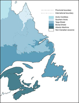
FIGURE 2: Terrestrial ecozones of Atlantic Canada. (after: Agriculture and Agri-Food Canada).
larger image
The ecological diversity of Atlantic Canada is demonstrated by the number of terrestrial ecozones (Figure 2; Environment Canada, 2005b) and ecoregions (Sabine and Morrison, 2002). Climate regions range from cool humid-continental through subarctic to arctic tundra, with the influence of the warm Gulf Stream in the south giving way to that of the cold Labrador Current in the north. Seasonal conditions reflect competing tropical and polar, continental and maritime influences. Along the Atlantic Ocean coastline, multi-decadal variability in weather systems and their effects, particularly in winter, are associated with the North Atlantic Oscillation (NAO; Marshall et al., 2001).
The Atlantic Maritime ecozone consists of Nova Scotia, Prince Edward Island, New Brunswick and the Gaspé region of Quebec (Figure 3a, b). The Gulf of St. Lawrence coast of New Brunswick forms a plain that slopes gently eastward, with long shallow embayments and salt marshes. Rolling to rugged uplands, with much terrain more than 200 m above sea level, characterizes western New Brunswick, the margins of the Bay of Fundy and most of Nova Scotia. Coastlines are deeply indented, dominated by cliffs and gravel beaches, and characterized by steep offshore bathymetry. The Nova Scotia coast of the Bay of Fundy has steep cliffs flanking the shoreline. Inland is a steep escarpment 120 to 150 m high. The topography of the low-lying plain of the Annapolis Valley, and the rolling hills of the Nova Scotia Uplands, trend northeast. Cape Breton Island has irregular hills, steep escarpments and flat-topped to rolling plateaus, dissected by short steep streams with numerous cataracts and waterfalls. Prince Edward Island is an undulating plain of low relief with well-developed sand dune and beach systems.
The Atlantic Maritime ecozone is the warmest in Atlantic Canada, with southern to mid-boreal climates. Mean winter temperatures range from –8 to –2°C (Environment Canada, 2005a). Mean summer temperatures vary regionally between 13 and 15.5 °C. Mean annual precipitation ranges between 800 and 1500 mm. The New Brunswick climate varies with distance from the Gulf of St. Lawrence coastline, as both moist Atlantic air from the Bay of Fundy and humid winds blowing from the New England and Great Lakes –St. Lawrence Lowland regions influence the region. Interior areas have a more continental climate, whereas regions along the Bay of Fundy have cool summers and mild winters. Fog is common in exposed coastal areas. Nova Scotia is constantly influenced by the ocean, but coastal regions of the province still have cooler springs and summers and milder winters than interior sites. Ice cover on the Gulf of St. Lawrence during winter brings cooler temperatures and a later spring. Prince Edward Island receives the strongest maritime influence of the three provinces, and has mild winters, late cool springs and moderate windy summers.
Mixed-wood forests are the primary vegetation in this ecozone. Red spruce, balsam fir, yellow birch and sugar maple are the main species, with significant numbers of red and white pine, and eastern hemlock. Acadian Forest assemblages were the pre –European settlement vegetation in most of Prince Edward Island, southeastern New Brunswick and sheltered areas of mainland Nova Scotia. Boreal species, such as white birch and black and white spruce, are also present. Shrubs in the ecozone consist of willow, pin cherry, speckled alder and blueberry. In terms of a natural resource –based economy, forest industries represent a major economic component of this ecozone, together with fisheries (mostly lobster, finfish and aquaculture) and local mining.
The island of Newfoundland, the southeastern corner of Labrador, and the shoreline of Lake Melville are part of the Boreal Shield ecozone (Figure 3c, d). The island of Newfoundland features diverse topography. The Avalon Peninsula has rolling uplands interspersed with small plateau regions, embayments, short rivers with steep-gradients and cliffs up to 65 m high. The central part of the island includes ridges interspersed with undulating terrain and small plateaus. Relief is generally less than 200 m. The coastline is ragged, marked by deep indentations, cliffed headlands and numerous islands and skerries. Locally, cliffs rise in excess of 100 m. Beaches are restricted to sheltered coves and are dominated by cobbles and pebbles. The western coast is a region of rugged topography, grading eastwards into rolling plateaus. Relief exceeds 800 m. A narrow costal plain discontinuously borders the western margin of the island.
Southeastern Labrador is rough and undulating, with isolated patches of permafrost. Elevation rises rapidly from the coast to 365 m above sea level. The area around Lake Melville is coastal lowland. To the south and west of the Lake Melville Plain, the terrain is dissected by river valleys, with some hills reaching 500 m.
Precipitation in this mid-boreal climate ranges from 900 to 2000 mm annually (Environment Canada, 1993, 2005a). Mean temperatures in the summer vary from 8.5 to 12.5 °C, whereas the winter range is –20 to –1°C. The topography causes storm systems to diverge, either along the west coast or across the Burin and Avalon peninsulas. Spring and summer are cool. Moderating ocean influences are most evident along the west and south coasts, which are washed by the Gulf of St. Lawrence and Gulf Stream, but are less apparent along the northeast coastline, which is influenced by the Labrador Current and the NAO. Interior sites have warmer summers and cooler winters than do adjacent coastal regions.
This ecozone is mostly forested, with black and white spruce, balsam fir, larch (tamarack), white birch and aspen poplar being the dominant species. Lichens and shrubs grow in areas of exposed bedrock. Although forestry is important in some parts of this ecozone, fisheries and mineral exploration are the main components of the resource-based economy.
The Taiga Shield ecozone encompasses most of Labrador (Figure 3e, f). It is marked by rolling topography, with generally less than 200 m of elevation difference between the deepest valleys and the adjacent summits in western Labrador. In contrast, the Mealy Mountains have rugged terrain. Elevations of the summits reach 1190 m, and areas of permafrost occur locally.
A northern boreal climate characterizes the Taiga Shield ecozone. The prevailing westerly winds bring dry air from northern Quebec, producing cold dry winters with calm days and minimal humidity in interior locations. Summers are short and cool with long days. Coastal locations are influenced by the Labrador Current, and have cooler summer conditions. Annual precipitation ranges from 800 mm in western regions to more than 1000 mm in areas along the coast (Environment Canada, 2005a). Mean winter temperatures vary from –25 to –10°C; summer means are between 6.5 and 10°C.
Vegetation varies from forests of black and white spruce and balsam fir to shrublands and meadows. Fens and bogs have alder, willow and larch (tamarack) in addition to the conifer species. Riverbanks and upland sites support white spruce, trembling aspen, balsam poplar and white birch. Mineral resources and hydroelectric power generation are the main economic activities.
The southernmost portion of the Arctic Cordillera ecozone contains the Torngat Mountains of northern Labrador (Figure 3g, h). The tundra climate in the Torngat Mountains is cold and humid with short, cool, moist summers and long, cold winters. Coastal ice may persist into July. Mean annual precipitation ranges from 400 to 700 mm, with higher values in central areas of high elevation. The mean winter temperature is –16.5°C and the summer mean is 4°C. Sheltered, south-facing valley slopes support patches of arctic mixed evergreen and deciduous shrubs, while other areas are sparsely covered with moss, lichen and sedges.
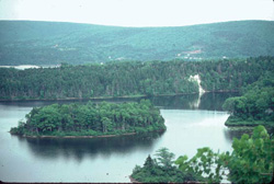
FIGURE 3a) Atlantic Maritime ecozone - mixed deciduous-coniferous forest, Cape Breton Highlands National Park, NS.
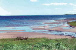
FIGURE 3b) Atlantic Maritime ecozone - mixed deciduous-coniferous forest, Cape Breton Highlands National Park, NS.
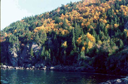
FIGURE 3c) Boreal Forest ecozone - spruce-fir-aspen forest assemblage, near Springdale, central Newfoundland.
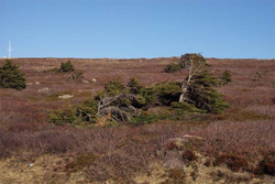
FIGURE 3d) Boreal Forest ecozone - exposed coastal barrens and tuckamore landscape, Cape Spear, Newfoundland.
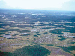
FIGURE 3e) Taiga Forest ecozone - aapa (ribbon fen) and black spruce assemblage, west of Pinus River, Labrador.
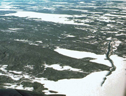
FIGURE 3f) Taiga Shield ecozone - forest terrain with esker, Molson Lake, western Labrador.
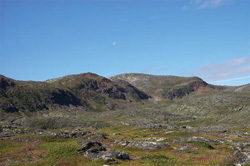
FIGURE 3g) Arctic Cordilleran ecozone - tundra landscape and vegetation, Hebron, Labrador.
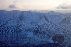
FIGURE 3h) Arctic Cordilleran ecozone - glacial cirques, Torngat Mountains, Labrador.
Page details
- Date modified: