
Characterization and Monitoring Change of Canada’s Land Surface
Rasim Latifovic, Richard Fernandes, Darren Pouliot, Ian Olthof
Land surface monitoring is required for assessment and prediction of weather, climate, biochemical cycling, hydrology, wildlife habitat, ecological status and trends. Such monitoring is important for understanding land-surface processes and their role in the exchange of water and energy through land-atmosphere interaction. Since land surface characteristics vary in time and space, mapping approaches that employ satellite-based Earth Observations (EO) at different spatial and temporal scales are used to obtain information on land cover type, land use, and other land surface attributes including albedo, leaf area index, and vegetation phenology. This EO-derived scientific information underpins strategies for land management aimed at achieving environmental, social and economic sustainability.
Objective:
The project objective is to develop new methods for monitoring and characterizing land surface at the national scale. Project research involves development of processing technology and information extraction methods, and also the assessment of new satellite missions for land surface characterization. The project outputs are used by ESS Programs such as Groundwater Geoscience and Climate Change Geoscience as well as other government, public, and private stakeholders.
Methods:
Natural resource management, environmental assessment, land monitoring and planning require frequently updated information on land cover status and condition over large areas. Support to an active monitoring effort at regional scale by manually extracting information through interpretation of EO data is labour intensive and not easily repeatable. To facilitate more efficient land cover monitoring, sophisticated algorithms based on advances in the fields of pattern recognition and machine learning are being investigated. Another essential pre-requisite for monitoring land surface conditions is the availability of satellite observations with high radiometric consistency and temporal frequency. The initial satellite-sensor observations are converted into geophysical variables through a series of processing steps including calibration, geolocation, reprojection, mosaicking, atmospheric correction, clear sky identification and compositing. Research to improve the processing steps assures data quality and increases consistency. Within the framework of this project, the national satellite data records that are currently maintained are generated from
- the Polar Operational Environmental Satellites (POES) of the National Oceanographic and Atmospheric Administration (NOAA),
- the Moderate Resolution Imaging Spectrometer (MODIS) of the National Aeronautics and Space Administration (NASA), and
- the MEdium Resolution Imaging Spectrometer (MERIS) and SPOT/VEGETATION of the European Space Agency (ESA).
Complementary satellite data at higher spatial resolution acquired by the ASTER, LANDSAT and SPOT imaging sensors are used as reference data to support national scale products calibration/validation efforts and for development of local to regional scale applications.
The project is organized into the following four activities:
- National Scale Satellite Data Records
- Land Cover Time Series Methodology and Products
- North American Land Cover
- Surface Biophysical Parameters
1. National Scale Satellite Data Records
CCRS has developed Long Term Satellite Data Records (LTSDR) for a series of optical sensors. These highly-processed records include AVHRR, SPOT-Vegetation, MODIS and MERIS. For the first three, records span over 25, 12 and 10 years, respectively. The MERIS record currently spans 3 years. The processing methodologies and software used to produce these LTSDR were developed by CCRS. Additional details on the LTSDR and processing methodologies will be added to this website shortly. In the interim, please contact rasim.latifovic@nrcan.gc.ca for additional information.
2. Land Cover Time Series Methodology and Products
a) Land cover
The Canada Center for Remote Sensing (CCRS) has produced a number of national scale land cover databases with 1km spatial resolution, including the land cover time series 1985 – 2005 from NOAA/AVHRR (Latifovic and Pouliot, 2005) and SPOT/VEGETATION data (Latifovic et al., 2004). The most recent land cover database of Canada (Figure 1), produced from 0.25km spatial resolution MODIS data, has improved accuracy, spatial resolution and thematic content. The new database includes two thematic layers based on the Federal Geographic Data Committee/Vegetation Classification Standard (FGDC/NVCS) modified for use in Canada and the International Geosphere Biosphere Program (IGBP) land cover classes. Accuracy of the new land cover database is assessed by degree of agreement with visually interpreted reference data and existing land cover products at higher spatial resolution (30m). Comparison with reference data showed ~70% accuracy using the primary and secondary reference label to account for mixed pixels. The comparison against independent reference data showed good agreement with land cover proportions from Statistics Canada, the Canadian Forest Service and Agriculture Canada. The new database served as the primary source of Canadian land cover information in the North America Land Cover database.
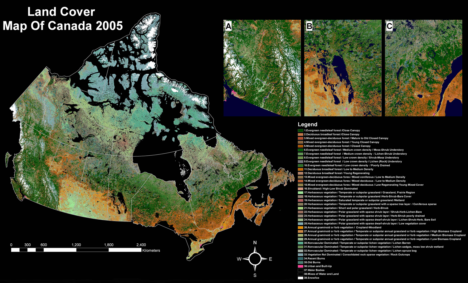
Figure 1 Land Cover Map of Canada 2005 derived from MODIS 250m spatial resolution data. Zoomed in examples from A) British Columbia, B) Manitoba, and C) Quebec
larger image
b) Land cover change
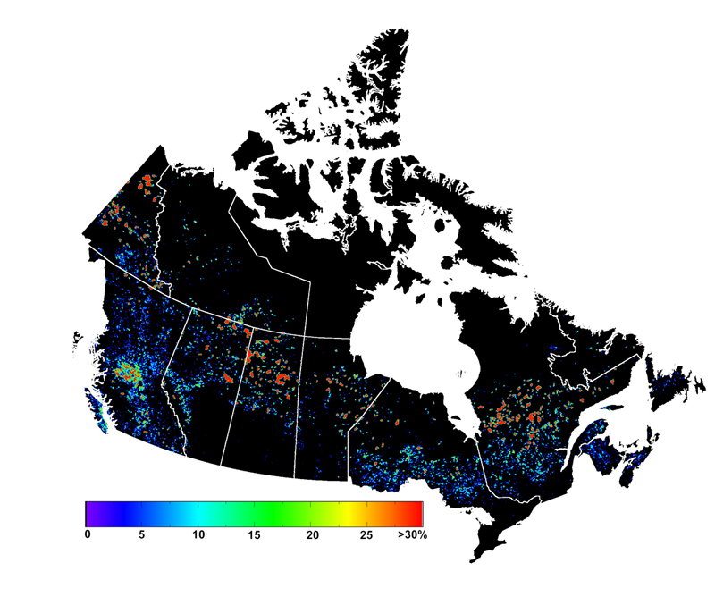
Research on change detection is focused on developing EO capacity for monitoring changes that currently are not comprehensively assessed at the national scale. It seeks to incorporate information from multiple temporal and spatial scales to achieve consistent and accurate results for monitoring land surface change in a semi-automated manner. In collaboration with other monitoring programs, a national scale synthesis is envisioned that will provide standardized information on change type, occurrence, and extent across Canada at annual to decadal scales. New methodology designed and developed to detect forest disturbances from MODIS observations is under evaluation in cooperation with the Canadian Forest Service. Example results are shown at the national scale (Figure 2) and for an example of forest harvesting in Quebec (Figure 3).

Figure 2a Percent change within an 8 km grid cell based on the MODIS forest disturbance change product (2001 vs. 2006). It reveals the nature and distribution of change in Canada with large fires in the north and smaller, but spatially more extensive changes to the south. The impact of the mountain pine beetle outbreak in central British Columbia is evident.
larger image
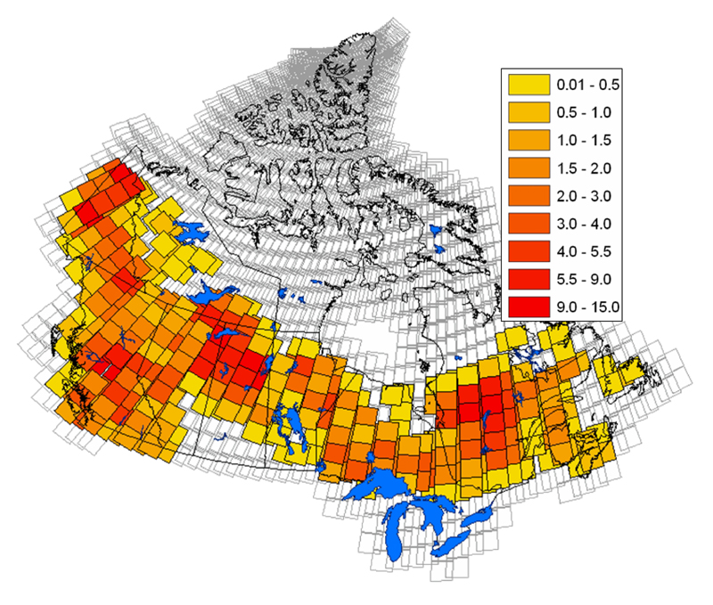
Figure 2b Shows the percentage change within a LANDSAT scene – information useful for prioritizing areas in need of finer scale analysis.
larger image
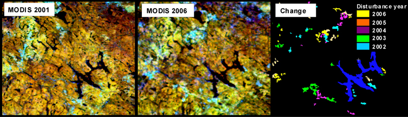
Figure 3 Example change detection results for forest harvesting in Quebec showing the delineation of changes spatially and temporally.
larger image
3. North American Land Cover

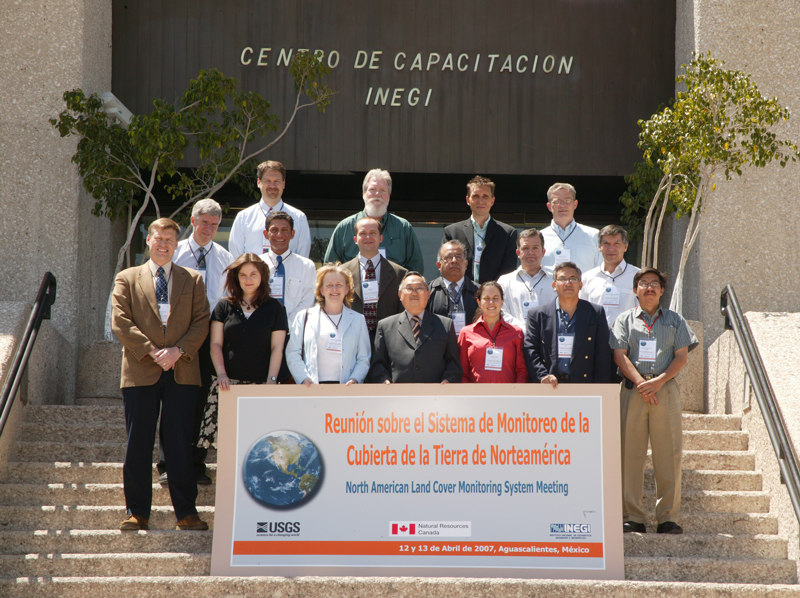
NALCMS project team
larger image
This project contributes to the development of the North American Land Change Monitoring System (NALCMS). CCRS is the Canadian partner in the NALCMS research collaboration that involves scientific organizations from the Mexican and US governments (USGS, INEGI , CONABIO , and CONAFOR ). It was initiated at the 2006 Land Cover Summit in Washington, D.C., and in the Summit proceedings is referred to as one of the most significant outcomes. The trilateral Commission for Environmental Cooperation and its Secretariat support and facilitate the NALCMS project collaboration.
A land cover monitoring system that is harmonized across North America’s political boundaries will provide information that simultaneously meets needs at the continental scale, while also providing information for each country to complement existing country specific monitoring programs. The tracking of land cover change will provide fundamental information for understanding the environmental impacts on the North American landscape due to disturbances such as fire, forest harvesting, insect damage, land use change and infrastructure and economic development. A better understanding of the dynamics and patterns of land cover change will support Canada, US and Mexico to address North American scale issues.
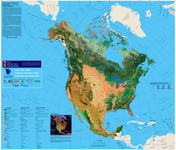
Land Cover Map of North America
larger image
The North American Land Cover Map produced by the NALCMS project is based on the MODIS satellite observations acquired during 2005. The first product of the NALCMS is now available to the public. The detailed 250m spatial resolution data underlying the map represents a harmonized base layer that will enable the tracking of land cover changes over time. Target users of the information provided by the NALCMS include decision makers, international organizations such as the United Nations Environment Programme, nongovernmental conservation organizations and scientific researchers in the domains of climate change, carbon sequestration, biodiversity loss, and changes in ecosystem structure and function. The system also serves other users with an interest in land cover dynamics and continental-scale patterns of North America’s changing environment.
4. Surface Biophysical Parameters
CCRS' Long Term Satellite Data Records, for the AVHRR, SPOT-Vegetation, MODIS and MERIS sensors, are being used to generate a variety of surface biophysical parameters. Leaf area index (LAI), snow cover, Normalized Difference Vegetation Index (NDVI), surface albedo are generated. Additional details on these parameters will be added to this website shortly. In the interim, please contact richard.fernandes@nrcan.gc.ca for additional information.
Latifovic, R., Pouliot, D., and Olthof, I., 2009 North American Land Change System: Canadian Perspective. 30th Canadian Symposium on Remote Sensing, Lethbridge, Alberta
Page details
- Date modified: