
Oceans & Coastal Monitoring
The oceans not only provide valuable food and biophysical resources, they also serve as transportation routes, are crucially important in weather system formation and CO² storage, and are an important link in the earth's hydrological balance. Understanding ocean dynamics is important for fish stock assessment, ship routing, predicting global circulation consequences of phenomena such as El Nino, forecasting and monitoring storms so as to reduce the impact of disaster on marine navigation, off-shore exploration, and coastal settlements. Studies of ocean dynamics include wind and wave retrieval (direction, speed, height) , mesoscale feature identification, bathymetry, water temperature, and ocean productivity.
Coastlines are environmentally sensitive interfaces between the ocean and land and respond to changes brought about by economic development and changing land-use patterns. Often coastlines are also biologically diverse inter-tidal zones, and can also be highly urbanized . With over 60% of the world's population living close to the ocean, the coastal zone is a region subject to increasing stress from human activity. Government agencies concerned with the impact of human activities in this region need new data sources with which to monitor such diverse changes as coastal erosion, loss of natural habitat, urbanization, effluents and offshore pollution. Many of the dynamics of the open ocean and changes in the coastal region can be mapped and monitored using remote sensing techniques.
Ocean applications of remote sensing include the following:
-
Ocean pattern identification:
- currents, regional circulation patterns, shears
- frontal zones, internal waves, gravity waves, eddies, upwelling zones, shallow water bathymetry ,
-
Storm forecasting
- wind and wave retrieval
-
Fish stock and marine mammal assessment
- water temperature monitoring
- water quality
- ocean productivity, phytoplankton concentration and drift
- aquaculture inventory and monitoring
-
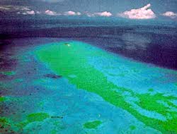
Oil spill
- mapping and predicting oilspill extent and drift
- strategic support for oil spill emergency response decisions
- identification of natural oil seepage areas for exploration
-
Shipping
- navigation routing
- traffic density studies
- operational fisheries surveillance
- near-shore bathymetry mapping
-
Intertidal zone
- tidal and storm effects
- delineation of the land /water interface
- mapping shoreline features / beach dynamics
- coastal vegetation mapping
- human activity / impact
Page details
- Date modified: