
Species Identification & Typing
Background
Forest cover typing and species identification are critical to both forest conservation managers and forestry companies interested in their supply inventory. Forest cover typing can consist of reconnaissance mapping over a large area, while species inventories are highly detailed measurements of stand contents and characteristics (tree type, height, density).
Why remote sensing?
Remote sensing provides a means of quickly identifying and delineating various forest types, a task that would be difficult and time consuming using traditional ground surveys. Data is available at various scales and resolutions to satisfy local or regional demands Large scale species identification can be performed with multispectral, hyperspectral, or airphoto data, while small scale cover type delineation can be performed by radar or multispectral data interpretation. Both imagery and the extracted information can be incorporated into a GIS to further analyze or present with ancillary data, such as slopes, ownership boundaries, or roads.
Hyperspectral imagery can provide a very high spatial resolution while capturing extremely fine radiometric resolution data. This type of detailed spectral information can be used to generate signatures of vegetation species and certain stresses (e.g. infestations) on trees. Hyperspectral data offers a unique view of the forest cover, available only through remote sensing technology.
Data requirements
Requirements depend on the scale of study to be conducted. For regional reconnaissance mapping, moderate area coverage, with a sensor sensitive to differences in forest cover (canopy texture, leaf density, spectral reflection) is needed. Multitemporal datasets also contribute phenology information that may aid in interpretation by incorporating the seasonal changes of different species.
For detailed species identification associated with forest stand analysis, very high resolution, multispectral data is required. Being able to view the images in stereo helps in the delineation and assessment of density, tree height, and species. In general, monitoring biophysical properties of forests requires multispectral information and finely calibrated data.
Canada vs. International
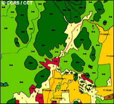
Current sources of data used operationally for forest cover typing and species identification applications within Canada are aerial photography, orthophotography, Landsat TM, and SPOT data. Landsat data are the most appropriate for executing reconnaissance level forest surveys, while aerial photography and digital orthophoto are the preferred data source for extracting stand and local inventory information. Airphotos are the most appropriate operational data source for stand level measurements including species typing. SAR sensors such as RADARSAT are useful where persistent cloud cover limits the usefulness of optical sensors.
In humid tropical areas, forest resource assessments and measurements are difficult to obtain because of cloudy conditions hindering conventional remote sensing efforts, and difficult terrain impeding ground surveys. In this situation, reliability of data acquisition is more crucial than resolution or frequency of imaging. An active sensor may be the only feasible source of data, and its reliability will facilitate regular monitoring. Radar will serve this purpose, and an airborne sensor is sufficient for high resolution requirements such as cover typing. This type of data can be used for a baseline map , while coarser resolution data can provide updates to any changes in the baseline.
Case study (example)
Inventory Branch, Ministry of Forests, Province of British Columbia, Canada
This is an example of the operational requirements and procedure for a provincial department involved in a number of forestry applications using remote sensing technology.
The Inventory Branch is responsible for maintaining a database of Crown Land information concerning historical, stand, and sustainable forest management information which is used for determining timber volumes and annual allowable cuts. The inventory itself is performed every ten years with 1:15,000 scale aerial photography, and updated with satellite imagery every two years.
The Inventory branch requires geocoded, terrain corrected data. For most studies, the branch currently buys precision geocoded data, and for large scale mapping projects, they will cut costs by obtaining systematic versus precision geocoded data. Further processing is done in-house on workstations. Some location data are now being provided by the private sector, conducting field traverses with GPS (global positioning system) data.
Present planimetric accuracy requirements are 20 m, but will be more demanding in the near future. Airphotos and orthophotos meet requirements and are good for interpretation but are limited by expense. Data continuity is important, as monitoring will be an ongoing operation. TM data for updating maps is reasonable in cost and information content for interim monitoring.
Much of the updating in the Ministry of Forests is done with TM data, either brought digitally into a MicroStation workstation to perform heads-up digitizing, or in transparency form with the image overlain onto existing maps using a projection device. The Ministry of Forests is presently investigating the potential of a number of data sources with various levels of processing applied, and integration possibilities to assess accuracy versus cost relationships.
The Ministry of Forests in B.C. employs an expert system SHERI (System of Hierarchical Expert Systems for Resource Inventories) to provide a link between remotely sensed data, GIS and growth and yield modelling. The end to end information flow is complete with the generation of final products including forest cover maps incorporating planimetric and administrative boundary information.
Case study (example)
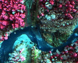
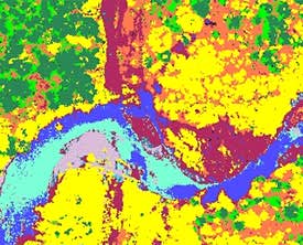
Hyperspectral image and recent stem count from hyperspectral imagery
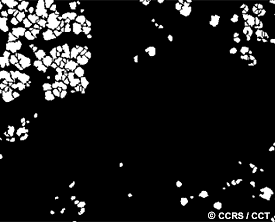
Forest companies use hyperspectral imagery to obtain stem counts , stand attributes, and for mapping of land cover in the forest region of interest. These images depict a false colour hyperspectral image of a Douglas fir forest on Vancouver Island at a resolution of 60 cm. The imagery was acquired in the fall of 1995 by the CASI (Compact Airborne Imaging Spectrometer). Attributes obtained from the imagery (a subset is shown) include:
- Stand Area (hectares) 9.0
- Total number of trees 520
- Tree density (stems/ha) 58
- Crown closure (%) 12.46
- Average tree crown area (sq m) 21.47
The corresponding land cover map contains the following classes:
- Dark green: conifers
- Green: lower branches
- Light purple: gravel
- Yellow: deciduous
- Orange: dry ground cover
- Red: wet ground cover
- Blue (light): water
- Blue (dark): deep or clear water
All imagery courtesy of MacMillan Bloedel and ITRES Research Limited.
Did you know?
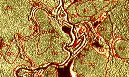
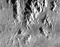
Forest interpretation from SAR data
Interpreting forest cover type with radar data is very similar to interpreting multispectral images. The same interpretation elements are used (tone, texture, shape, pattern, size, association), but texture plays a dominant role in the discrimination of different forest types. Viewing the images in stereo helps to differentiate relative tree heights, as well as define rivers that have specific vegetation along their banks.
Page details
- Date modified: