
Answer to question 2
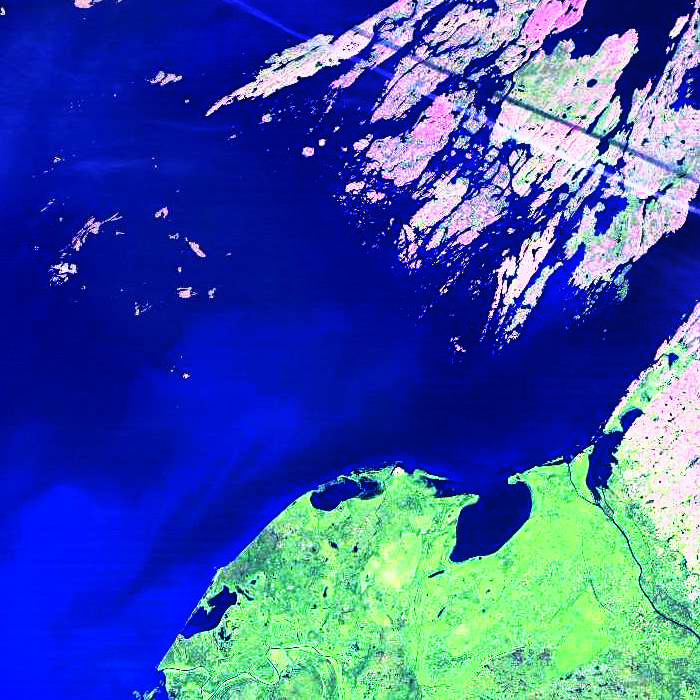
Landsat 5 TM image of the eastern end of Great Slave Lake.
The diagonal white line at the top right of the image is:
- paved road
- contrail
- hydro line
- gravel road
The answer is B.
A. No.
A road wouldn't be as straight as this line, nor would it cross water bodies without a bridge!
B. Yes.
An aircraft condensation trail is not limited to land or water. The parallel contrail shadow just above it confirms this feature and also gives a mechanism for calculating the altitude of the contrail (the date and time of the image identifies the sun angle and the horizontal offset of contrail and shadow can be measured from the image).
C. No.
Usually a hydro line is visible because the right-of-way has been cleared of vegetation. But it would not be visible while crossing water bodies, as it is here.
D. No.
The same reasoning goes here as for a paved road. A road wouldn't be as straight as this line, nor would it cross water bodies without a bridge!
Did You Know?
By knowing the time that the satellite image was recorded, we can determine the sun angle (above the horizon). With that parameter, as well as the horizontal distance on th image between an object (such as the contrail) and its shadow, we can calculate the height of that object above the Earth's surface. This is the relationship:
h = height of the object above the Earth's surface
d = horizontal distance between object and shadow
θs = angle of the sun above the horizon
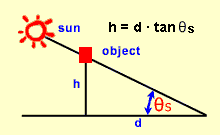
diagram illustrating the calculation of height
h = d * tan θs
Page details
- Date modified: